
The Flat Earth Reality
نمایش بیشتر
12 324
مشترکین
+224 ساعت
+27 روز
+7630 روز
توزیع زمان ارسال
در حال بارگیری داده...
Find out who reads your channel
This graph will show you who besides your subscribers reads your channel and learn about other sources of traffic.
تجزیه و تحلیل انتشار
| پست ها | بازدید ها | به اشتراک گذاشته شده | ديناميک بازديد ها |
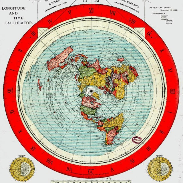
01 Temple architects in the Indian subcontinent followed a code called "Vastushastra" since ancient times and most of the temples were built mainly facing the east direction. You can think of these ancient temples as having directional signs carved into stones that are thousands of years old. Today, if you check their direction using a magnetic compass, their original direction has not deviated even a bit. This disproves the magnetic pole shifting theory, according to which the magnetic north pole has shifted about 1100 km since 1831.
E.g. The Angkor Wat temple complex in Cambodia is an ancient Hindu temple that was built at least 900 years ago. Right in the center of the temple, you will find a square carving on the floor. When you center the compass, it aligns perfectly with the 4 cardinal directions with a 0° error. | 497 | 12 | Loading... |
02 Media files | 2 345 | 6 | Loading... |
03 The U.S. Secretary of Defense Wants to Replace GPS
https://warroom.armywarcollege.edu/articles/lost
“I hate GPS. The idea that we are all hooked to a satellite…that doesn’t work in certain circumstances, does not work indoors or in valleys in Afghanistan, is ridiculous.”
– Ashton Carter,
Former U.S. Secretary of Defense,
June 2014.
The US, UK, Russia and China are building ground-based PNT (Position, Navigation and Timing) networks as an alternative or backup to their respective GNSS (Global Navigation Satellite System) PNT networks. One of their goals is to integrate GNSS with eLORAN, WiFi and 4G/5G cellular services.
The reason they give is that the GNSS signal is vulnerable to jamming, spoofing, solar flares or physical attacks on the satellite infrastructure. But this argument is nonsensical as the mentioned vulnerabilities are also applicable to all other so-called communication satellites. Also if their GNSS is truly global these countries can share their GNSS access to create redundancy.
They also state that the weak strength of GNSS signals due to the MEO (>20,000 km) orbit is one reason for their unreliability or unavailability. So why don't they plan a new GNSS satellite constellation in LEO orbit capable of transmitting high radio power levels? Which will greatly improve signal strength and availability.
So are they creating excuses to justify the use of land based PNT networks while maintaining the illusion of navigation satellites? | 2 989 | 32 | Loading... |
04 The US, EU, Russia and China all have their own satellite based navigation services such as GPS, so why are their governments and military authorities still expanding and developing land based and other navigation systems? | 2 997 | 33 | Loading... |
05 Why GPS satellites in "space" is a hoax
▪️The fact that the Earth itself is flat and stationary disproves the orbiting space satellite theory.
▪️Then there is impossibility of satellite hardware (onboard electronics and batteries) operating in extreme temperatures (upto 2000°C) of so called thermosphere while orbiting at an insane speed of 3.9 km/s (> mach 11).
▪️ Commercial and military aviation do not use GPS as a primary navigation system. And till this date aircrafts could not be tracked using GPS and satellite communication. ATCs around the world still use ground-based radar to track airplanes.
▪️Modern smartphones use assisted GPS (A-GPS) to determine location using cell phone data services, WiFi signals, and "ground-based GPS data servers", because so-called GPS satellite signals are very weak, unreliable, dependent on atmospheric conditions, and also aren't available in some areas.
▪️ Even if your smartphone doesn't have a SIM card, it can scan cell site signals from all operators in the area and update its GPS tracking unit by getting a location fix. Almost all portable GPS tracking units such as those installed in vehicles require cellular service to function.
▪️ It's no coincidence that commercial gps units were first introduced in 1990s after the 2G cellular services were launched. eg. This newspaper article from 2009 explains "why commercial use of GPS has not taken off in India due to various reasons including patchy telecom network signals in rural areas and national highways.
▪️If GPS is a universal and reliable navigation system, different countries around the world will not build new eLOAN and ground based gps psudolite stations. | 4 432 | 100 | Loading... |
06 GPS is primarily a ground based system that uses a combination of mobile cell tower signals from all operators and pseudolite (pseudo-satellite) ground based antennas. Airborne (HAPS based) pseudolites can be deployed for navigation in remote areas where fiber optics connectivity or mobile cell towers are not available. | 4 449 | 63 | Loading... |
07 The Duga radar, was a part of the Soviet Union’s early warning system to detect incoming missiles. The Soviets built two, DUGA-1 near the now-abandoned town of Chernobyl, and DUGA-2 in Siberia.
The DUGA-1 located in Southern Ukraine, and was able to detect rocket launches at the Baikonur Cosmodrome 2575 km away. This means DUGA-1 could detect a moving target hidden 457 km behind the Earth's bulge! where its range should have been limited by the globe horizon at 43 km. Wikipedia explains it as an OTH (over the horizon) radar that uses ionospheric reflection signals to detect targets.
But according to IEEE (Institute of Electrical and Electronics Engineers), radars require line of sight (LOS) to function. Ionospheric reflection signals makes no sense because radar relies on measuring the time delay between the (direct LOS) transmitted and reflected radio signals and ionospheric reflection signals (if they really exist) are not usable for radar application. The IEEE quotes "Ionosphere instability affects the radar image and thus induces poor detection and a high probability of false alarms." This means that radars can only work reliably if the Earth is truly flat and stationary. | 4 212 | 68 | Loading... |
08 Media files | 3 519 | 34 | Loading... |
09 Media files | 586 | 14 | Loading... |
10 Cooperation between different nations for space missions like the ISS, Preparation for planetary defence against doomsday situations like worldwide pandemics, nuclear war, alien invasion, asteroid impacts, giant intercontinental tsunamis or a sudden ice age due to climate change...One theme is common throughout all of this fear programming and that is, they all are elaborate hoaxes concocted by the NWO conspirators to establish a one world government. | 5 629 | 55 | Loading... |
11 Developed in 1960s, the INS (Inertial Navigation Systems) was a collection of extremely precise accelerometers and gyroscopes, used to calculate and display an object’s position, speed and direction relative to a known starting point. eg. Once an aircraft's or submarine’s INS is calibrated to a known reference point, it can “dead reckon” the target accurately from that point forward. The earlier INS did not take into account the curvature of the Earth and pilots could still navigate using this basic navigation system. | 7 272 | 108 | Loading... |
12 An aircraft autopilot adjusts cruising altitude (pitch angle) only to account for changes in weight (due to fuel burning or dumping) and atmospheric wind pressure conditions, but never for the curvature of the imaginary globe. | 6 465 | 86 | Loading... |
13 The aircraft autopilot makes altitude (pitch angle) corrections for loss of weight (fuel) and change in atmospheric wind pressure conditions except for the curvature of the imaginary globe. | 1 | 0 | Loading... |
14 A rotating earth is a witchcraft. It affects pendulum, bullet and football trajectories but somehow does not affect the flight path and flight duration of the aircraft. 🤡 | 5 503 | 87 | Loading... |
15 In 2014 the US Air Force lied to Congress that it was shutting down the HAARP facility in Alaska. | 6 815 | 93 | Loading... |
16 An experiment 6 months ago has now become a conspiracy theory. 😏 | 8 683 | 197 | Loading... |
17 Chinese astronauts take 4-hour spacewalk outside the Tiangong space station on Sept. 17, 2022. | 9 184 | 131 | Loading... |
18 The Chinese space agency doesn't even bother to add curvature. 🤦 | 10 326 | 158 | Loading... |
19 Billionaire businessman John Catsimatidis, chairman and CEO of United Refining Company, admits in an April 4, 2022 interview that oil is infinite and produced by the earth, and does not come from dead dinosaurs, as they said.
https://t.me/TheFlatEarthReality/2034
https://t.me/TheFlatEarthReality/2131 | 9 478 | 300 | Loading... |
Temple architects in the Indian subcontinent followed a code called "Vastushastra" since ancient times and most of the temples were built mainly facing the east direction. You can think of these ancient temples as having directional signs carved into stones that are thousands of years old. Today, if you check their direction using a magnetic compass, their original direction has not deviated even a bit. This disproves the magnetic pole shifting theory, according to which the magnetic north pole has shifted about 1100 km since 1831.
E.g. The Angkor Wat temple complex in Cambodia is an ancient Hindu temple that was built at least 900 years ago. Right in the center of the temple, you will find a square carving on the floor. When you center the compass, it aligns perfectly with the 4 cardinal directions with a 0° error.
👍 4💯 4❤ 1
According to the British Geological Survey, Earth's magnetic north pole is moving from its current position towards Siberia at a rate of 55 km/year.
Do you believe in this magnetic pole shifting theory?Anonymous voting
- Yes
- No
- I don't know
👍 8
The U.S. Secretary of Defense Wants to Replace GPS
https://warroom.armywarcollege.edu/articles/lost
“I hate GPS. The idea that we are all hooked to a satellite…that doesn’t work in certain circumstances, does not work indoors or in valleys in Afghanistan, is ridiculous.”
– Ashton Carter,
Former U.S. Secretary of Defense,
June 2014.
The US, UK, Russia and China are building ground-based PNT (Position, Navigation and Timing) networks as an alternative or backup to their respective GNSS (Global Navigation Satellite System) PNT networks. One of their goals is to integrate GNSS with eLORAN, WiFi and 4G/5G cellular services.
The reason they give is that the GNSS signal is vulnerable to jamming, spoofing, solar flares or physical attacks on the satellite infrastructure. But this argument is nonsensical as the mentioned vulnerabilities are also applicable to all other so-called communication satellites. Also if their GNSS is truly global these countries can share their GNSS access to create redundancy.
They also state that the weak strength of GNSS signals due to the MEO (>20,000 km) orbit is one reason for their unreliability or unavailability. So why don't they plan a new GNSS satellite constellation in LEO orbit capable of transmitting high radio power levels? Which will greatly improve signal strength and availability.
So are they creating excuses to justify the use of land based PNT networks while maintaining the illusion of navigation satellites?
👍 16🤣 14💯 10🔥 2🤡 1
Photo unavailableShow in Telegram
The US, EU, Russia and China all have their own satellite based navigation services such as GPS, so why are their governments and military authorities still expanding and developing land based and other navigation systems?
💯 24👍 8😎 2❤ 1
Why GPS satellites in "space" is a hoax
▪️The fact that the Earth itself is flat and stationary disproves the orbiting space satellite theory.
▪️Then there is impossibility of satellite hardware (onboard electronics and batteries) operating in extreme temperatures (upto 2000°C) of so called thermosphere while orbiting at an insane speed of 3.9 km/s (> mach 11).
▪️ Commercial and military aviation do not use GPS as a primary navigation system. And till this date aircrafts could not be tracked using GPS and satellite communication. ATCs around the world still use ground-based radar to track airplanes.
▪️Modern smartphones use assisted GPS (A-GPS) to determine location using cell phone data services, WiFi signals, and "ground-based GPS data servers", because so-called GPS satellite signals are very weak, unreliable, dependent on atmospheric conditions, and also aren't available in some areas.
▪️ Even if your smartphone doesn't have a SIM card, it can scan cell site signals from all operators in the area and update its GPS tracking unit by getting a location fix. Almost all portable GPS tracking units such as those installed in vehicles require cellular service to function.
▪️ It's no coincidence that commercial gps units were first introduced in 1990s after the 2G cellular services were launched. eg. This newspaper article from 2009 explains "why commercial use of GPS has not taken off in India due to various reasons including patchy telecom network signals in rural areas and national highways.
▪️If GPS is a universal and reliable navigation system, different countries around the world will not build new eLOAN and ground based gps psudolite stations.
Commercial use of GPS technology still to pick up in India
Commercial use of GPS technology still to pick up in India
👍 27💯 16👏 3🤔 2❤ 1
GPS is primarily a ground based system that uses a combination of mobile cell tower signals from all operators and pseudolite (pseudo-satellite) ground based antennas. Airborne (HAPS based) pseudolites can be deployed for navigation in remote areas where fiber optics connectivity or mobile cell towers are not available.
👍 24💯 13❤ 1
The Duga radar, was a part of the Soviet Union’s early warning system to detect incoming missiles. The Soviets built two, DUGA-1 near the now-abandoned town of Chernobyl, and DUGA-2 in Siberia.
The DUGA-1 located in Southern Ukraine, and was able to detect rocket launches at the Baikonur Cosmodrome 2575 km away. This means DUGA-1 could detect a moving target hidden 457 km behind the Earth's bulge! where its range should have been limited by the globe horizon at 43 km. Wikipedia explains it as an OTH (over the horizon) radar that uses ionospheric reflection signals to detect targets.
But according to IEEE (Institute of Electrical and Electronics Engineers), radars require line of sight (LOS) to function. Ionospheric reflection signals makes no sense because radar relies on measuring the time delay between the (direct LOS) transmitted and reflected radio signals and ionospheric reflection signals (if they really exist) are not usable for radar application. The IEEE quotes "Ionosphere instability affects the radar image and thus induces poor detection and a high probability of false alarms." This means that radars can only work reliably if the Earth is truly flat and stationary.
👍 25💯 21❤ 4👏 3
Photo unavailableShow in Telegram
Cooperation between different nations for space missions like the ISS, Preparation for planetary defence against doomsday situations like worldwide pandemics, nuclear war, alien invasion, asteroid impacts, giant intercontinental tsunamis or a sudden ice age due to climate change...One theme is common throughout all of this fear programming and that is, they all are elaborate hoaxes concocted by the NWO conspirators to establish a one world government.
💯 46👏 6👍 3❤ 2🤬 2